
Coast-to-Coast Chaos: Potent March Storm Threatens Severe Weather Outbreak
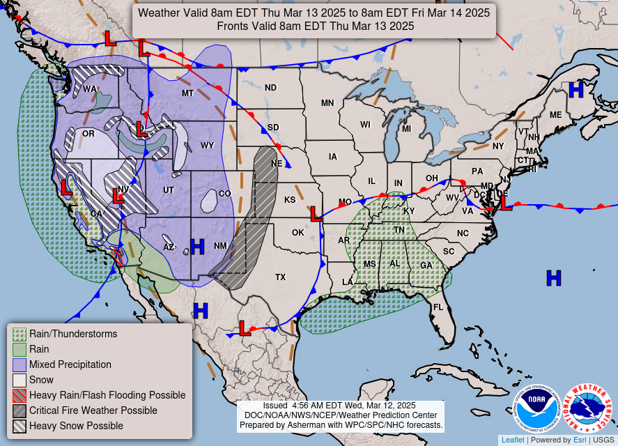
A powerful March storm system, already making its presence felt across the country, is poised to unleash a significant severe weather outbreak across the central and eastern United States this Friday and Saturday, according to AccuWeather forecasters. The expansive system threatens over 100 million people with a wide array of hazardous conditions, ranging from blizzard conditions in the northern Plains to the potential for tornadoes and wildfires in the South.
The storm’s initial impact is being felt in the West, where it continues to deliver heavy mountain snow and strong winds to the Sierra Nevada. Coastal southern California is also experiencing heavy rainfall. The National Weather Service warns of treacherous, and potentially impossible, travel conditions below many major passes across the Sierra Nevada and northern California higher terrain due to powerful wind gusts, ranging from 40 to 70 mph, combined with heavy snowfall. These conditions are expected to persist through Thursday, significantly impacting travel and potentially isolating communities.
While the most intense severe weather is anticipated for Friday and Saturday, the Storm Prediction Center has indicated a possibility of isolated severe thunderstorms on Thursday from eastern Mississippi into Alabama, western Georgia, and parts of the Florida Panhandle. These thunderstorms could produce hail and locally damaging wind gusts, serving as a precursor to the more widespread and intense weather to come. Residents in these areas are advised to remain vigilant and monitor weather updates throughout the day.
The primary concern revolves around a regional outbreak of severe storms expected across much of the Mississippi Valley, extending eastward to the Lower Ohio and Tennessee Valleys, late Friday afternoon into early Saturday morning. The Storm Prediction Center emphasizes that all severe hazards are possible within this region, including swaths of intense winds and the potential for tornadoes. The combination of atmospheric instability, strong wind shear, and ample moisture will create a highly favorable environment for the development of supercell thunderstorms capable of producing significant damage.
AccuWeather meteorologist Bernie Rayno highlights the potential for these severe thunderstorms to maintain their strength well past midnight on Friday, as they race eastward. He predicts a high number of severe weather reports, stating, "We expect as many as two dozen or more tornadoes, as well as hundreds of reports of damaging wind gusts, by the end of this weekend." This underscores the widespread and potentially devastating nature of the impending weather system.
A particularly concerning aspect of this storm is the potential for strong tornadoes to strike after dark on Friday. AccuWeather senior director of forecasting operations Dan DePodwin emphasizes the heightened danger associated with nighttime tornadoes, particularly during the overnight hours when many people are asleep. He urges residents in the affected areas to take proactive measures to ensure their safety. “Please take time now to make sure your storm shelter or safe room is ready for use and stocked with emergency supplies in case a tornado warning is issued in your community," DePodwin advises, emphasizing the importance of preparedness and a well-defined safety plan. This includes having a battery-operated weather radio, flashlights, extra batteries, water, and non-perishable food readily available. Families should discuss their plan and ensure everyone knows where to go in the event of a tornado warning.
In addition to the severe thunderstorm threat, the storm system is also creating conditions conducive to wildfires across the southern high Plains. The National Weather Service warns of dry, warm, and windy conditions that will promote critical fire weather conditions on Thursday and throughout the rest of the week. Residents in these areas are urged to exercise extreme caution with any potential ignition sources, such as outdoor burning or machinery that could generate sparks. The combination of dry vegetation and strong winds could lead to rapid fire spread, posing a significant risk to lives and property.
The storm is also influencing temperatures across the central and eastern U.S., with above-average temperatures expected for the next few days. While this may provide some temporary relief from the colder temperatures of winter, it also contributes to the instability of the atmosphere, increasing the potential for severe weather.
As the storm system progresses eastward, it will also bring snow to the northern Plains late Friday through Saturday. Weather.com meteorologist Chris Dolce indicates that snow is possible from northern Nebraska to the Dakotas and western and northern Minnesota. While snow totals are not expected to be heavy, high winds in combination with the snowfall could whip up blizzard conditions in spots, leading to dangerous travel conditions. These blizzard conditions could significantly reduce visibility and make travel extremely hazardous, if not impossible. Motorists in these areas are advised to avoid travel if possible and to monitor weather updates closely.
The widespread nature of this storm system underscores the importance of staying informed and taking appropriate precautions. Residents across the affected areas should closely monitor weather forecasts from reliable sources, such as the National Weather Service and local news outlets. They should also heed any warnings or advisories issued by local authorities. Preparedness is key to mitigating the risks associated with this potent March storm and ensuring the safety of lives and property. This includes having a plan in place for severe weather, ensuring access to emergency supplies, and staying informed about the latest weather developments. Taking proactive steps now can help minimize the potential impact of this significant weather event.