
Mount Spurr Alert: Increased Volcanic Activity Signals Potential Eruption in Alaska
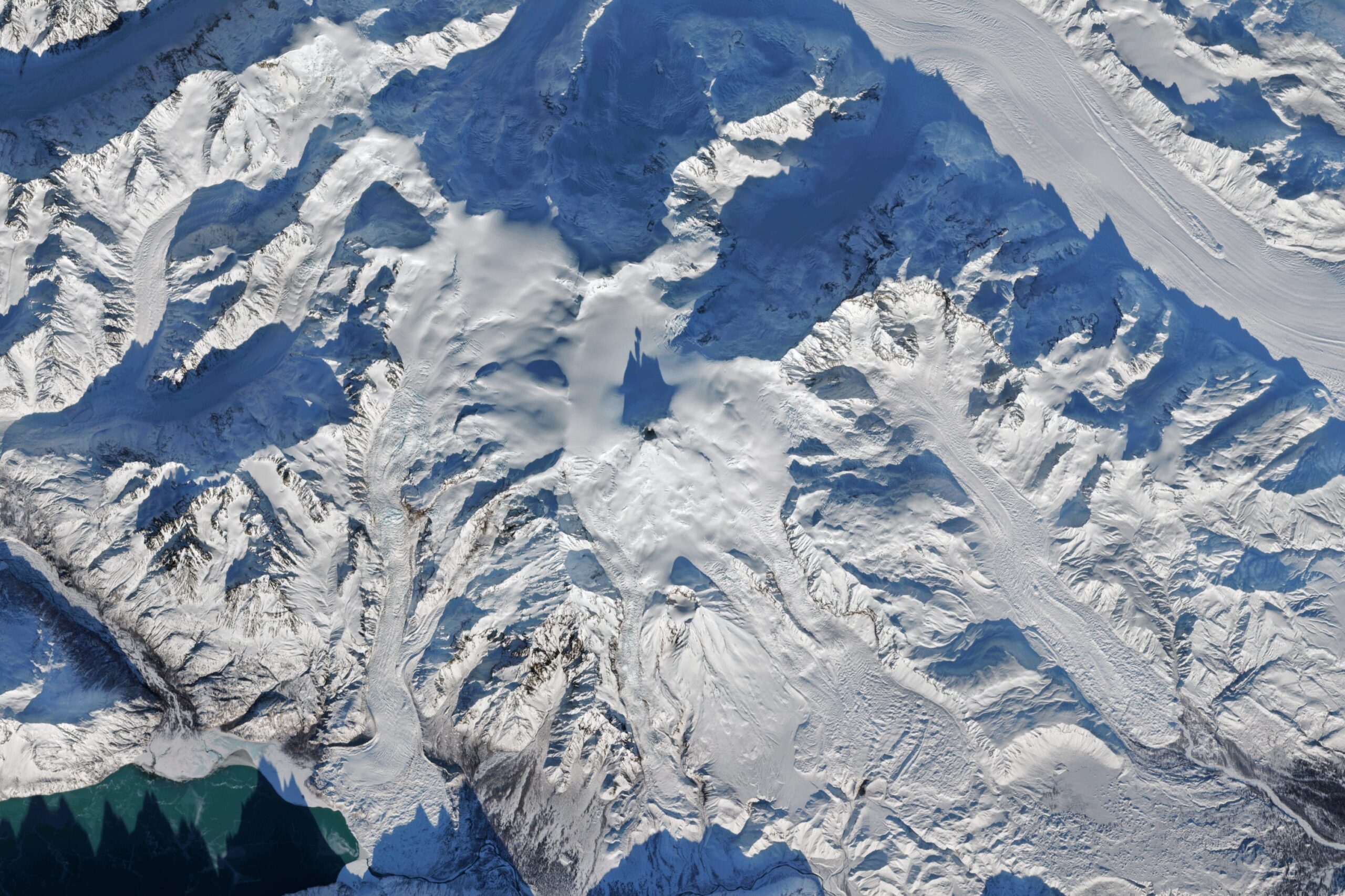
Government officials have issued an alert regarding Mount Spurr, a volcano located approximately 75 miles west of Anchorage, Alaska, indicating a heightened risk of eruption in the near future. The announcement, made Wednesday afternoon, follows a period of significantly increased volcanic activity observed by the Alaska Volcano Observatory.
The primary concern stems from the intrusion of fresh magma into the Earth’s crust beneath the volcano. This influx of molten rock is driving a series of changes, including the reactivation of gas fissures, or fumaroles, at Mount Spurr’s Crater Peak. These fumaroles are releasing increased amounts of volcanic gases, providing a key indicator of the escalating unrest beneath the surface.
Adding to the concern are notable increases in both earthquake activity and ground deformation around the volcano. These observations, meticulously tracked by the United States Geological Survey (USGS), suggest that the magma chamber beneath Mount Spurr is becoming increasingly pressurized, raising the potential for a forceful eruption.
While scientists cannot pinpoint the exact timing of a potential eruption, the recent surge in gas emissions recorded on March 7 has prompted a heightened state of alert. The USGS, in its official news release, stated that this development suggests an eruption could occur within the next few weeks to months.
The agency believes that magma has likely been accumulating beneath the 11,070-foot summit for several months, gradually building pressure within the volcanic system. Mount Spurr is prominently visible from Anchorage, the state’s most populous city, underscoring the potential impact of an eruption on the region.
A significant eruption of Mount Spurr could severely disrupt air traffic, posing challenges for both domestic and international flights. The volcano’s past eruptions in 1953 and 1992 offer a stark reminder of the potential consequences. These events, which lasted for several hours, produced substantial ash clouds that were carried downwind, leading to airport closures, impacts on water supplies, and ashfall of up to a quarter-inch throughout southcentral Alaska.
During those past eruptions, volcanic ash plumes reached heights of up to 45,000 feet into the atmosphere, disrupting air travel between the U.S. and Asia. The ash clouds interfered with the critical great circle routes that connect cities like New York and Tokyo along the Earth’s curve, highlighting the volcano’s potential to impact global air transportation networks.
The USGS anticipates that a similar eruption pattern is likely in the event of renewed activity. However, the agency is optimistic that continued monitoring of seismic activity, gas emissions, and surface heating will provide "days to weeks of additional warning" before any possible eruption. This additional warning time could be crucial for implementing safety measures and mitigating potential disruptions.
Despite the expectation of additional warning signs, the agency also cautioned that an eruption could occur with little or no further indication. Such a scenario would pose significant hazards for people in the surrounding areas and for aircraft navigating the airspace near the volcano. The possibility of a sudden, unheralded eruption underscores the need for vigilance and preparedness.
In addition to the direct hazards of ashfall and air travel disruption, the USGS warned that elevated levels of carbon dioxide and sulfur dioxide released from the volcano may pose a threat to those in low-lying areas around or downwind of the gas vents. Carbon dioxide is particularly dangerous due to its colorless and odorless nature, making it difficult to detect without specialized equipment. Exposure to high concentrations of these gases can pose serious health risks.
Prior to the latest developments, observatory officials had categorized Mount Spurr with a "yellow" advisory level, reflecting a state of unrest observed for approximately 11 months. This preliminary alert level indicated the potential for increased activity but did not suggest an imminent eruption. The recent surge in volcanic activity has prompted a reassessment of the risk level and a renewed focus on monitoring efforts.
Mount Spurr is part of a string of volcanoes located in the Aleutian Islands, a geologically active region that forms part of the Ring of Fire. This extensive zone of volcanic and seismic activity encircles the Pacific Ocean, resulting from the interaction of tectonic plates. In the case of the Aleutian Islands, the Ring of Fire is created by the Pacific plate sinking beneath the North American plate, a process known as subduction.
Volcanologists have identified evidence of multiple significant eruptions of Mount Spurr throughout its geological history. These eruptions, which occurred around 1650, 3200 BC, 5500 BC, and 6000 BC, indicate a pattern of recurring activity over long periods. This historical record suggests a cycle of major eruptions occurring roughly every 1,000 years or so.
Michael Manga, a volcanologist at the University of California, Berkeley, has previously commented on this cyclical pattern, highlighting the volcano’s tendency to produce significant eruptions at relatively regular intervals. While the exact timing of future eruptions remains uncertain, the historical record provides valuable insights into the potential scale and frequency of volcanic events at Mount Spurr.
The current situation underscores the dynamic nature of volcanic systems and the challenges involved in predicting eruptions. Ongoing monitoring efforts and scientific research are crucial for understanding the behavior of Mount Spurr and for mitigating the potential risks associated with future eruptions. The alert issued by government officials serves as a reminder of the need for preparedness and awareness in communities located near active volcanoes.