
California’s Sinking Shores: A Looming Crisis for Coastal Communities
California, the Golden State, known for its stunning coastline, vibrant cities, and agricultural abundance, faces a growing threat: sinking land. This phenomenon, termed "vertical land motion," is occurring at alarming rates in certain regions, exacerbating the impacts of rising sea levels and posing significant challenges to coastal communities and infrastructure. A recent study conducted by NASA’s Jet Propulsion Laboratory (JPL) and the National Oceanic and Atmospheric Administration (NOAA) sheds light on the extent and causes of this critical issue.
The study identifies specific areas across California experiencing either upward or downward land movement. These movements are driven by a combination of natural factors, such as tectonic plate shifts, and human activities, primarily groundwater extraction. The implications are far-reaching, particularly for densely populated coastal cities like San Francisco and Los Angeles, where the consequences of sinking land combined with rising sea levels could be devastating.
Marin Govorcin, the study’s lead author and a remote sensing scientist at JPL, emphasizes the severity of the situation. "In many parts of the world, like the reclaimed ground beneath San Francisco, the land is moving down faster than the sea itself is going up." This stark reality underscores the urgency of understanding and addressing the factors contributing to land subsidence in vulnerable coastal areas.
The Central Valley’s Sinking Crisis: A Consequence of Groundwater Depletion
The Central Valley, California’s agricultural heartland, is experiencing the most dramatic land subsidence in the state. Due to extensive groundwater extraction, especially during periods of drought, the earth is sinking at rates of up to 8 inches per year in some locations. Farmers and agricultural businesses rely heavily on groundwater to irrigate crops, and with dwindling surface water supplies, particularly during dry spells, the demand for groundwater intensifies. This excessive pumping depletes underground aquifers, causing the land above to compact and sink.
The sinking of the Central Valley has significant implications for infrastructure. Canals, aqueducts, and pipelines that transport water across the region are susceptible to damage and disruption as the ground shifts beneath them. The costs of repairing and maintaining this critical infrastructure could be substantial, impacting water delivery and agricultural productivity.
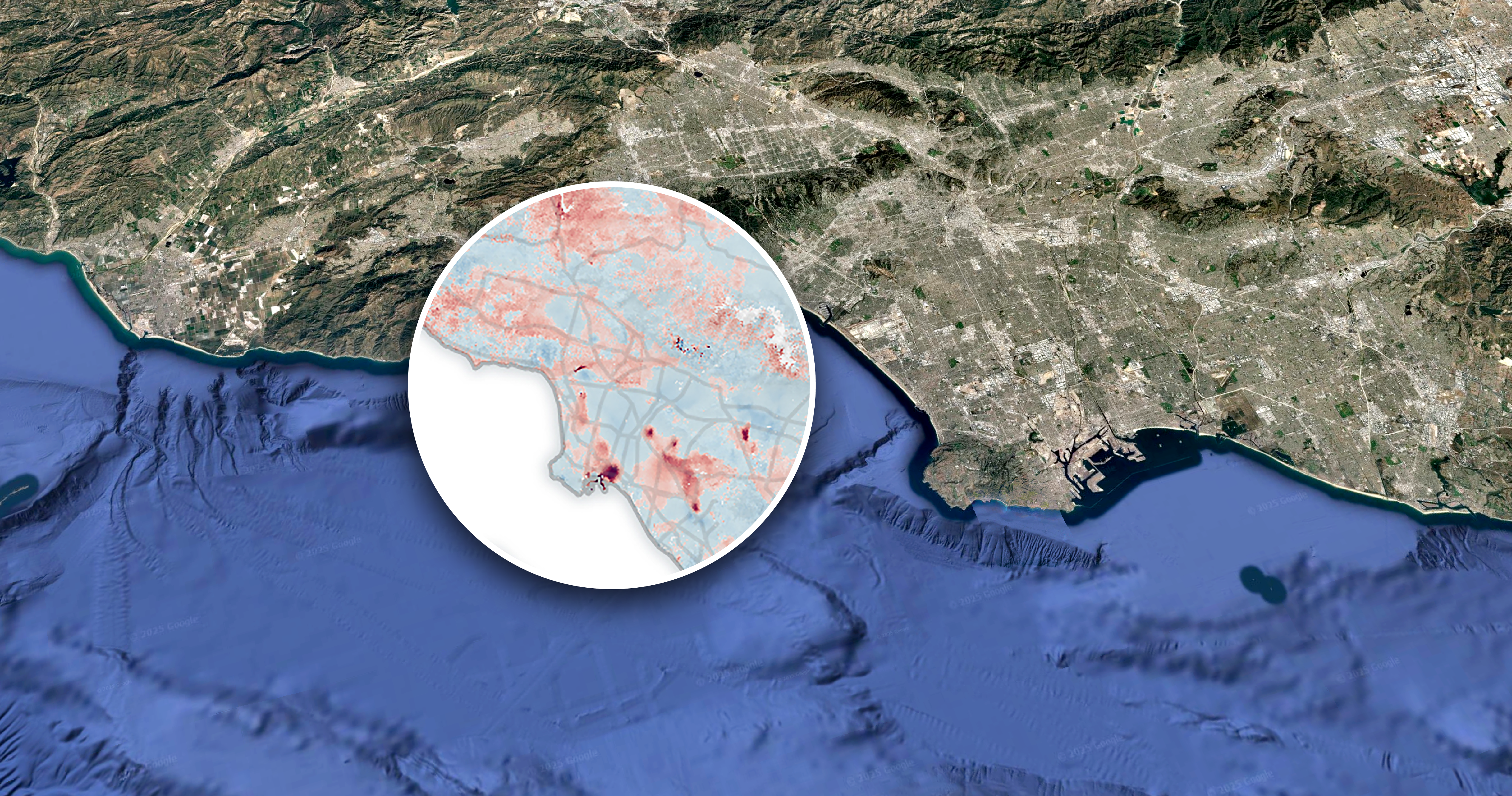
Coastal Hotspots: Sea Level Rise and Land Subsidence Converge
In coastal areas near San Francisco, the land is sinking at a rate of more than 0.4 inches per year, contributing to the threat of rising sea levels. According to projections, California’s sea levels are expected to increase by 6 to 14.5 inches (15 to 37 centimeters) by 2050 compared to the levels in 2000. This rise will exacerbate the impacts of land subsidence, increasing the risk of flooding, coastal erosion, and saltwater intrusion into freshwater sources.
Several coastal locations have been identified as "hotspots" where the combined effects of sea level rise and land subsidence pose the greatest threat. These areas require focused attention and strategic planning to mitigate the potential consequences.
Palos Verdes Peninsula: Landslides and Coastal Instability
The Palos Verdes Peninsula, known for its scenic beauty, faces a distinct challenge: slow-moving landslides. Heavy rainfall and erosion are believed to be the primary drivers behind this phenomenon, pushing the peninsula towards the ocean. A recent JPL analysis revealed that the region moved by 16 inches towards the ocean in just four weeks during the fall, a rate of approximately 4 inches per week. Alexander Handwerger, who conducted the JPL analysis, cautioned that this speed is "more than enough to put human life and infrastructure at risk."
The instability of the Palos Verdes Peninsula highlights the complex interplay of geological processes, weather patterns, and human activities in shaping coastal environments. Addressing the landslide risk requires a comprehensive understanding of the underlying causes and the implementation of appropriate mitigation measures.
Uplift in Santa Barbara and Long Beach: A Glimmer of Hope
Despite the widespread challenges of land subsidence, the study also identified areas experiencing uplift. The Santa Barbara groundwater basin, which has been continuously replenishing since 2018, shows rising areas of several millimeters per year. This positive trend suggests that effective water management practices can help reverse land subsidence and restore ground elevation.
In Long Beach, uplift has also been observed in areas where fluid extraction and injection occur with oil and gas production. This phenomenon indicates that controlled fluid injection can help stabilize the ground and counteract subsidence caused by extraction activities.
Beyond California: A Global Issue
The problem of sinking land is not confined to California. Parts of Hawaii, Chicago, and New York City are also experiencing land subsidence due to shifting or settling earth and the weight of skyscrapers. This global issue demands international collaboration and the sharing of knowledge and best practices to address the challenges of land subsidence and sea level rise.
The Path Forward: Monitoring, Adaptation, and Mitigation
NASAs scientists are committed to continued monitoring of coastal areas to gain a deeper understanding of how local elevation changes can inform strategies for communities to adapt to rising sea levels. This ongoing research is crucial for developing effective adaptation measures and informing policy decisions related to coastal management and infrastructure planning.
Addressing the sinking shores of California requires a multifaceted approach encompassing:
- Enhanced Monitoring: Implementing advanced monitoring technologies, such as satellite radar and GPS, to track land movements with greater precision.
- Sustainable Groundwater Management: Adopting and enforcing stricter regulations on groundwater extraction to prevent depletion of aquifers and reduce land subsidence.
- Infrastructure Investment: Investing in infrastructure upgrades and resilience measures to protect coastal communities from the impacts of flooding and erosion.
- Land Use Planning: Implementing land use policies that discourage development in vulnerable coastal areas and promote sustainable development practices.
- Public Awareness: Raising public awareness about the risks of land subsidence and sea level rise and engaging communities in the development of solutions.
By embracing these strategies, California can work toward mitigating the effects of sinking land and safeguarding its coastal communities for future generations. The challenges are significant, but with a concerted effort, the Golden State can navigate this crisis and ensure a resilient future for its iconic coastline.