
Severe Tornado Outbreak Threatens Multiple States Across the South and Southeast
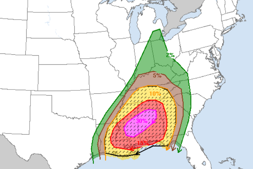
A significant and dangerous severe weather event is unfolding across a wide swath of the southern and southeastern United States, with forecasters warning of the potential for a widespread tornado outbreak on Saturday. The National Weather Service (NWS) and AccuWeather are both emphasizing the seriousness of the situation, urging residents in the affected areas to prepare for potentially devastating conditions. The primary threat zone encompasses the central Gulf Coast, the Deep South, and the Tennessee Valley, with the possibility of long-track tornadoes causing widespread damage and disruption.
The NWS is forecasting the highest risk across eastern Louisiana and Mississippi during Saturday afternoon. As the day progresses, the threat is expected to shift eastward, impacting Alabama, western portions of the Florida Panhandle, and Georgia. Residents in these areas should remain vigilant and stay informed about the evolving weather conditions.
The NWS issued a stark warning on Friday, highlighting the potential for strong tornadoes to develop across the lower to middle Mississippi and Tennessee valleys on Saturday. These tornadoes could be particularly dangerous due to their potential intensity and longevity. The severe weather is not limited to tornadoes, as the NWS also anticipates widespread lightning, damaging wind gusts reaching speeds of at least 74 mph, and hail exceeding two inches in diameter. These accompanying hazards will further exacerbate the dangers posed by the tornadoes. The severe weather threat is expected to persist through Sunday, affecting parts of the valleys and the broader Southeast region.
Given the speed and intensity of these storms, the NWS is emphasizing the importance of preparedness. Residents are strongly encouraged to develop a comprehensive severe weather plan, including identifying safe shelter locations and establishing communication protocols. The NWS also stresses the need for multiple ways to receive weather alerts, such as through smartphone apps, weather radios, and local news broadcasts. Relying on a single source of information can be risky, especially during power outages or communication disruptions.
AccuWeather has issued an "extreme risk" warning, its most severe weather category, for the first time since May 26, 2024. This rare designation underscores the exceptional danger posed by the impending storm system. AccuWeather meteorologists believe the elevated threat level will persist until after daylight hours on Saturday, creating a particularly hazardous situation, especially since many residents may be asleep or otherwise unaware of the immediate danger.
The combination of factors, including the potential for strong, long-track tornadoes, damaging winds, large hail, and widespread lightning, makes this severe weather event particularly dangerous. The fast-moving nature of the storms adds another layer of complexity, as residents may have limited time to react once a warning is issued.
While the exact path and intensity of the tornadoes are impossible to predict with certainty, forecasters are using advanced weather models and radar technology to monitor the situation closely and provide timely updates to the public. The public is strongly encouraged to follow the guidance of local emergency management officials and heed all warnings issued by the NWS and other reputable weather sources.
To prepare for the severe weather, residents in the affected areas should take the following steps:
- Develop a severe weather plan: Identify a safe room or shelter location, such as a basement, storm cellar, or interior room on the lowest level of a building. Ensure that everyone in the household knows the plan and understands what to do in the event of a tornado warning.
- Gather emergency supplies: Assemble a kit containing essential items such as water, food, medications, flashlights, batteries, a first-aid kit, and a weather radio.
- Stay informed: Monitor weather forecasts and alerts from the NWS and other reputable sources. Have multiple ways to receive warnings, such as a weather radio, smartphone app, and local news broadcasts.
- Secure outdoor objects: Bring in any loose outdoor items that could be blown away by strong winds, such as patio furniture, trash cans, and lawn decorations.
- Trim trees and shrubs: Remove any dead or weakened branches that could fall and cause damage during a storm.
- Know the warning signs: Be aware of the signs that a tornado may be approaching, such as a dark or greenish sky, large hail, a loud roar or rumble, and a visible funnel cloud.
- If a tornado warning is issued: Seek shelter immediately in a pre-designated safe room or shelter location. If you are in a car or mobile home, abandon it and seek shelter in a sturdy building.
The areas facing the greatest risk should brace for significant disruptions, including power outages, road closures, and property damage. Emergency responders are preparing for the possibility of widespread damage and potential search and rescue operations. Communities are also coordinating to provide shelter and support to those who may be displaced by the storms.
It is crucial for residents to understand that the threat of severe weather is not limited to the specific areas under tornado watches or warnings. The entire region is at risk of experiencing damaging winds, large hail, and heavy rain. Therefore, everyone in the affected area should take precautions and stay informed about the evolving weather conditions.
The safety and well-being of residents in the affected areas is paramount. By taking proactive steps to prepare for the severe weather, individuals and communities can minimize the risk of injury and damage. Staying informed, having a plan, and acting quickly when warnings are issued are essential for navigating this dangerous situation.