
A Symphony of Storms: NASA Satellites Capture a Rare Tropical Cyclone Convergence in the Southern Hemisphere
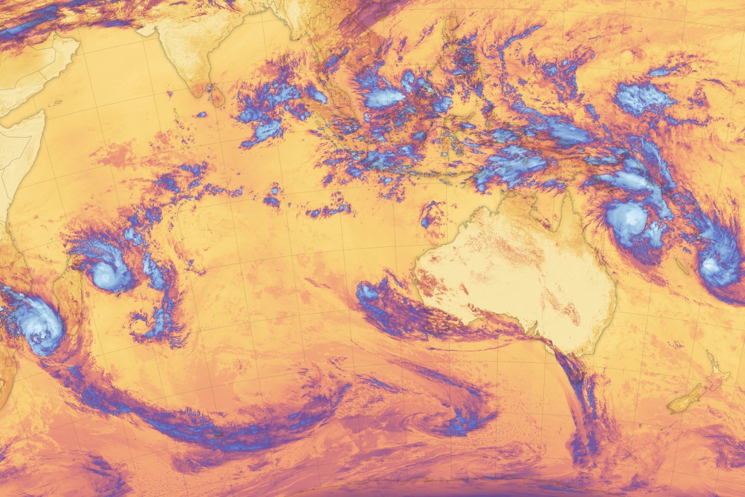
In a stunning display of Earth’s dynamic weather systems, NASA satellite imagery has recently captured a rare convergence of tropical cyclones swirling across the Southern Hemisphere’s oceans. The images, a testament to the power of space-based observation, reveal a dramatic scene of three active cyclones churning in the Pacific Ocean alongside another trio spiraling across the Indian Ocean. This simultaneous activity underscores the intensity of weather patterns across a vast expanse of the Southern Hemisphere and highlights the indispensable role of NASA satellites in monitoring these powerful storm systems from low-Earth orbit.
The remarkable images were acquired by the National Oceanic and Atmospheric Administration’s (NOAA) NOAA-20 satellite, utilizing its Visible Infrared Imaging Radiometer Suite (VIIRS) sensor. This advanced instrument is designed to capture high-resolution imagery of Earth’s surface, providing scientists with invaluable data on atmospheric conditions, sea surface temperatures, and other critical environmental factors. The VIIRS sensor’s ability to penetrate cloud cover allows for detailed observation of storm structure and intensity, making it an essential tool for tracking and forecasting tropical cyclones.
In the Pacific Ocean, the storms were christened Alfred and Seru. Meanwhile, the Indian Ocean was grappling with Bianca, Garance, and Honde. A NASA false-color image captured on February 26th offers a stark visual of the storm’s positions. Garance and Honde are depicted swirling on either side of Madagascar, their powerful arms reaching out to impact the island nation. Further east, Bianca lurks off the west coast of Australia, a reminder of the potential for severe weather to impact the continent. Alfred and Seru are situated east of northern Australia, their presence adding to the already complex weather patterns in the region.
According to a NASA Earth Observatory release, the image was taken a day after a sixth storm had weakened to the point of unidentifiability. This storm had previously brought heavy rainfall to the island nation of Fiji, highlighting the widespread impact of these weather systems on vulnerable communities. Despite the dissipation of the sixth storm, the remaining cyclones continue to pose a significant threat to coastal regions and maritime activities.
Seru, one of the Pacific cyclones, reached Category 1 strength on the Saffir-Simpson scale, the standard measure for classifying the intensity of hurricanes and cyclones. This classification indicates that Seru is capable of producing sustained winds of 74-95 miles per hour, potentially causing damage to trees, power lines, and unsecured structures. Alfred, another Pacific cyclone, was initially observed as a Category 2 storm but rapidly intensified to Category 4 status the following day. This rapid intensification underscores the dynamic nature of tropical cyclones and the importance of continuous monitoring.
Tropical Cyclone Bianca, located in the Indian Ocean, was nearing the end of its lifespan at the time of the satellite imagery. It achieved Category 3 strength on February 25th but remained far from land, minimizing its potential impact on populated areas. However, the storm weakened significantly to a tropical storm the following day, demonstrating the complex interplay of factors that influence cyclone intensity.
The other storms in the Indian Ocean, Garance and Honde, remained powerful systems with the potential to impact land. Madagascar, in particular, was facing the threat of heavy rain, strong winds, and storm surge as these cyclones approached. Storm surge, the abnormal rise in sea level during a storm, can inundate low-lying coastal areas, causing widespread flooding and damage. The combination of these factors poses a significant risk to communities in Madagascar, emphasizing the need for preparedness and effective disaster management strategies.
According to the NASA release, warm sea surface temperatures and weak wind shear may have contributed to the formation and intensification of these storms. Warm water provides the necessary energy for tropical cyclones to develop, while weak wind shear allows the storm’s structure to remain intact. The absence of strong winds aloft prevents the cyclone from being torn apart, allowing it to intensify and organize.
The conditions that fueled these cyclones are not isolated incidents. Warmer-than-average surface water temperatures, combined with low vertical wind shear, also contributed to the rapid intensification of Hurricane Milton last year. Milton intensified from a Category 1 storm into a Category 5 event in a mere seven hours, demonstrating the potential for these conditions to create extremely dangerous weather systems.
A marine heatwave has been lingering in the waters west of Australia since September, indicating a sustained period of unusually warm ocean temperatures. NOAA has observed particularly high sea surface temperatures in the area this month, further highlighting the potential for cyclone formation and intensification.
Despite these contributing factors, it is important to note that this is the typical season for tropical cyclones in the Southern Hemisphere. These storms generally form between November and April, coinciding with the warmer months and favorable atmospheric conditions. However, the frequency and intensity of tropical cyclones are influenced by a complex interplay of factors, including climate change, making it challenging to predict long-term trends.
The satellite imagery serves as a powerful reminder of the utility of spacecraft in monitoring climatological processes on Earth. These observations provide scientists with invaluable data on weather patterns, sea surface temperatures, and other critical environmental factors. Continuous monitoring of the planet’s surface is essential for understanding and predicting the impacts of climate change and developing effective strategies for mitigating its effects.
The NASA and Indian Space Research Organization (ISRO) mission NISAR is set to launch this year, promising to further enhance our ability to observe and measure changes to Earth’s surface with unprecedented precision. NISAR will use synthetic aperture radar (SAR) technology to collect data on land deformation, ice sheet dynamics, and other critical environmental processes. This mission will provide scientists with a wealth of new information, enabling them to better understand the complex interactions between Earth’s systems and improve our ability to predict future changes.