
Rethinking Hurricane Warnings: New Maps and Inland Focus from the National Hurricane Center
As the Atlantic hurricane season approaches, officially commencing on June 1st, the National Hurricane Center (NHC) is preparing to roll out significant changes to its communication strategy, prioritizing a broader understanding of hurricane risks that extend far beyond coastal regions. The core of this new approach revolves around reimagined maps designed to illuminate the widespread potential for damage from tropical cyclones, regardless of their initial landfall point. These maps represent a departure from traditional forecasts, which often prioritize the storm’s trajectory and immediate coastal impacts.
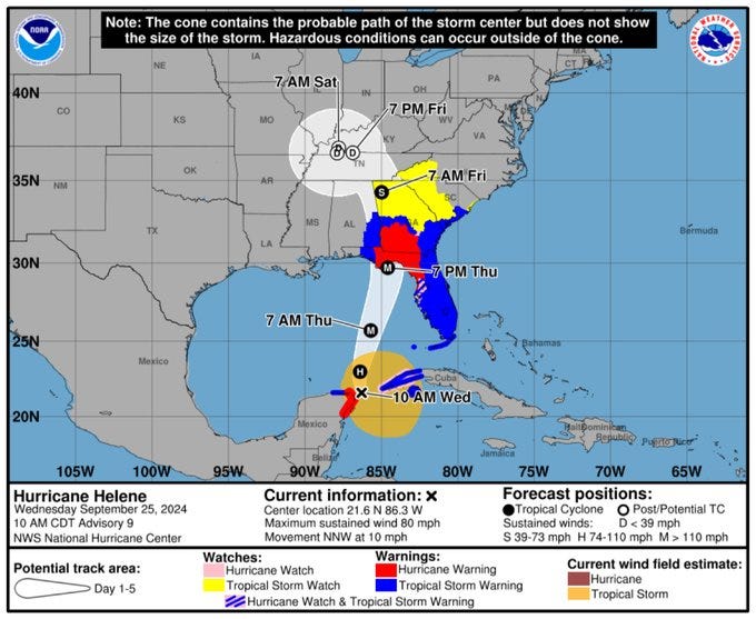
The impetus behind this shift stems from the realization that the devastation caused by hurricanes and tropical storms isn’t solely confined to the coastline. History has shown that some of the most severe consequences can manifest hundreds of miles inland. A case in point is Hurricane Helene, which made landfall near Steinhatchee, Florida, last year. While the coastal area experienced its share of impacts, the storm’s most destructive effects were felt in western North Carolina, nearly 400 miles away. This serves as a stark reminder that the reach of these powerful weather systems is often underestimated, leading to inadequate preparedness in inland communities. Hurricane Helene’s overall impact was devastating, claiming the lives of 248 people and causing an estimated $78.7 billion in damage across affected regions.
Recognizing this vulnerability, the NHC’s new maps aim to visually represent the extended reach of hurricane-related threats. The updated graphics will be noticeably different from the familiar forecast images, placing greater emphasis on highlighting the swaths of the nation that face potential risks from tropical cyclones. The new, more colorful map could even become the standard for hurricane warnings next year.
The NHC is also bringing back the experimental version of the cone graphic which will include inland tropical storm and hurricane watches and warnings that are in effect for the continental United States. The graphic is hoped to make it easier for people to spot storm risks and to assist state and local leaders, families, and communities in staying ahead and safe, whether they’re near the coasts or in the heartland.
The NHC is taking the addition of inland watches and warnings to the cone graphic because of social science research that suggests it will help communicate wind risk during tropical cyclone events without overcomplicating the current version of the graphic with too many data layers. The experimental cone legend will now contain the symbology for areas where a hurricane watch and tropical storm warning are simultaneously in effect.
The goal of these changes is to foster a more proactive and informed response to hurricane threats, regardless of geographical location. By providing a clearer picture of the potential risks, the NHC hopes to empower individuals, families, and communities to take necessary precautions and mitigate the potential for harm.
Robbie Berg, hurricane center warning coordination meteorologist, highlighted the importance of this change stating, "The only real change is the slight modification to the legend for a simultaneous hurricane watch/tropical storm warning. The legend issue was the only main concern we received from the experimental period last year. Well see if we get any major feedback this season, and then well reassess about possibly making the product operational in 2026. It was always our intention to make the new cone experimental for at least two seasons to allow a large window for comments from users."
To ensure the effectiveness and usability of the new maps, the NHC is implementing a phased rollout. The effort started in 2024 and is expected to become more visible this year. The experimental graphic was available via a link next to the operational/legacy cone on the hurricane center website last year. The NHC is working to make this more visible this season, however there are no decisions yet.
The NHC understands that integrating new information into existing warning systems requires careful consideration. As a result, the experimental graphic may not be available as soon as the current cone graphic because of the time needed to compile complete inland watch and warning information. However, it is expected that it will be available within 30 minutes of the advisory release. Also, there could be technical issues that affect the timeliness or availability of the graphic during the experimental phase. The public will have the ability to provide comments and feedback during the product’s experimental phase.
The NHC recognizes the importance of public feedback in refining its communication tools. Throughout the experimental phase, there will be ample opportunities for individuals, emergency managers, and other stakeholders to provide their input on the new maps. This feedback will be crucial in shaping the final version of the product and ensuring that it effectively meets the needs of diverse communities. The aim is to create a warning system that is both scientifically sound and easily understandable, empowering people to make informed decisions and take appropriate action to protect themselves and their property.
The upcoming hurricane season presents an opportunity to test the effectiveness of these new communication strategies and gather valuable insights into their impact on public awareness and preparedness. As the NHC continues to refine its approach, it remains committed to providing accurate, timely, and accessible information to help individuals and communities navigate the challenges posed by these powerful storms. By expanding the focus beyond the immediate coastline, the NHC hopes to create a more comprehensive understanding of hurricane risks and foster a culture of preparedness that extends throughout the nation.