
Midwest Braces for Blizzard, Southern Plains Face Wildfire Threat as Powerful Storm System Sweeps the Nation
A strengthening spring storm system churning across the Midwest on Wednesday threatens to unleash blizzard conditions across a wide swath of the region. At the same time, powerful winds associated with the same weather system are expected to elevate wildfire risks from drought-stricken Texas extending northward into the southern High Plains. This potentially devastating storm follows closely on the heels of a recent severe weather event that tragically claimed the lives of over 40 individuals across the country, highlighting the volatile nature of weather patterns this spring.
The current storm, characterized by a deep area of low pressure, is predicted to dump heavy snow across the Central Plains before pivoting northeastward through the Upper Midwest and Upper Great Lakes regions through Thursday. According to forecaster Paul Ziegenfelder, writing on the Weather Prediction Center website, snowfall rates could reach up to two inches per hour. When coupled with wind gusts exceeding 50 mph, these conditions are highly conducive to the formation of blizzards.
Ziegenfelder specifically identified the area from northern Kansas through southern Minnesota as being at the greatest risk for experiencing blizzard conditions. The combination of intense snowfall and strong winds is expected to result in near-zero visibility at times, creating extremely hazardous and potentially impassable travel conditions. Authorities are urging residents in the affected areas to avoid unnecessary travel and to take precautions to ensure their safety.
The dangers posed by this storm are multifaceted, extending beyond the immediate threat of blizzard conditions. The parched landscape of Texas and the southern High Plains is facing an elevated risk of wildfires due to the strong, gusty winds associated with the storm system. These winds could easily ignite dry vegetation, leading to rapidly spreading and difficult-to-control wildfires. Fire weather warnings have been issued for parts of the region, and residents are being advised to exercise extreme caution to prevent accidental ignitions.
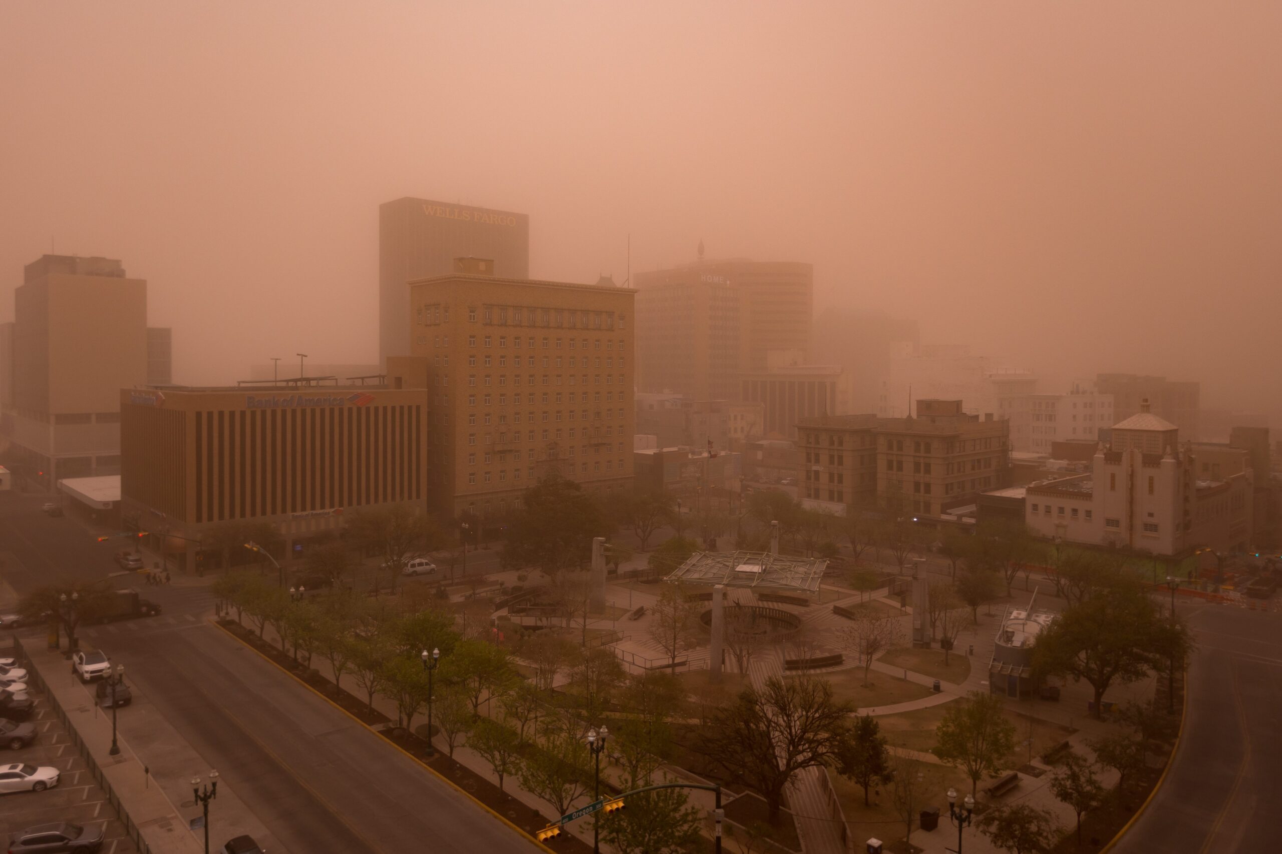
The impact of the wind has already been felt in some areas. A dust storm swept through El Paso, Texas, on Tuesday, turning the skies a sandy color and significantly reducing visibility. The National Weather Service in El Paso advised residents to stay off the roads due to the hazardous conditions. Notably, the top recorded wind gust on Tuesday reached a staggering 101 mph at 4:40 p.m. in the San Agustin Pass east of Las Cruces, New Mexico, according to the NWS. Another impressive wind gust of 93 mph was recorded at approximately 3 p.m. at the same location. These figures illustrate the sheer power of the winds associated with this storm system.
Adding to the already complex weather situation, the National Weather Service Storm Prediction Center has issued an enhanced risk of severe thunderstorms over portions of the Mississippi and Ohio Valleys, as well as the Upper Great Lakes, through Thursday morning. This enhanced risk indicates a heightened probability of severe weather events, including severe thunderstorms, hail, and potentially multiple tornadoes.
Forecasters are particularly concerned about the possibility of strong tornadoes developing within these thunderstorms. They have cautioned that some of these tornadoes could be powerful, and they have not ruled out the possibility of EF5 tornadoes, which are capable of producing wind gusts exceeding 200 mph. The potential for such destructive tornadoes adds another layer of urgency to the weather warnings and underscores the importance of taking necessary safety precautions.
In summary, a powerful spring storm system is poised to bring a variety of weather hazards to different parts of the country. The Midwest is bracing for blizzard conditions, while the southern High Plains face an elevated risk of wildfires. Simultaneously, the Mississippi and Ohio Valleys, along with the Upper Great Lakes, are under an enhanced risk of severe thunderstorms and tornadoes. Residents in all affected areas are urged to stay informed about the latest weather forecasts and warnings, heed the advice of local authorities, and take appropriate measures to protect themselves and their property. The combination of these weather threats creates a potentially dangerous situation, requiring vigilance and preparedness from all those in the storm’s path. It is a stark reminder of the power and unpredictability of nature and the importance of respecting the forces of weather.