
Hurricane Idalia’s Intensity: A Fresh Perspective on a Costly Storm
Hurricane Idalia, a devastating storm that struck the United States in August 2023, inflicted billions of dollars in damages and left a trail of destruction across Florida and the Southeast. While the typical factors that fuel hurricane intensification were present, a recent study suggests that a previously overlooked element played a significant role in Idalia’s rapid strengthening: freshwater plumes.
A team of researchers delved into the climatic conditions surrounding Hurricane Idalia, and their findings, published in Environmental Research Letters, offer a fresh perspective on the storm’s unusual intensity. The team discovered that the conventional combination of warm sea surface temperatures, abundant ocean heat beneath the surface, and low vertical wind shear, while contributing to Idalia’s development, did not fully explain its rapid escalation.
The researchers focused on the presence of a freshwater plume, originating from river discharge into the Gulf of Mexico. This plume created a density gradient between the surface water and the deeper, cooler water below. This density difference acted as a barrier, preventing the mixing of warmer surface waters with the cooler depths. As a result, Idalia was able to continuously draw strength from the warm Gulf surface, intensifying at an alarming rate.
"Wind wants to mix the water, bringing cold water up to the surface and warm water down to the depths," explained marine scientist Chuanmin Hu, one of the study’s authors. "But the density gradient between surface fresh water and deeper salty water makes this difficult." This insight sheds light on how freshwater plumes can significantly influence hurricane behavior.
Historical data supports the connection between river plumes and hurricane intensification. According to the NASA Earth Observatory release, over two-thirds of storms between 1960 and 2000 that reached Category 5 strength at some point in their lifecycles passed over regions with historical freshwater plumes. This highlights the potential for river plumes to contribute to the development of extremely powerful hurricanes.
"If you have a persistent river plume in the right location at the right time," Hu stated, "you may have a perfect storm." This statement underscores the potential for freshwater plumes to act as a critical factor in hurricane intensification when combined with other favorable atmospheric and oceanic conditions.
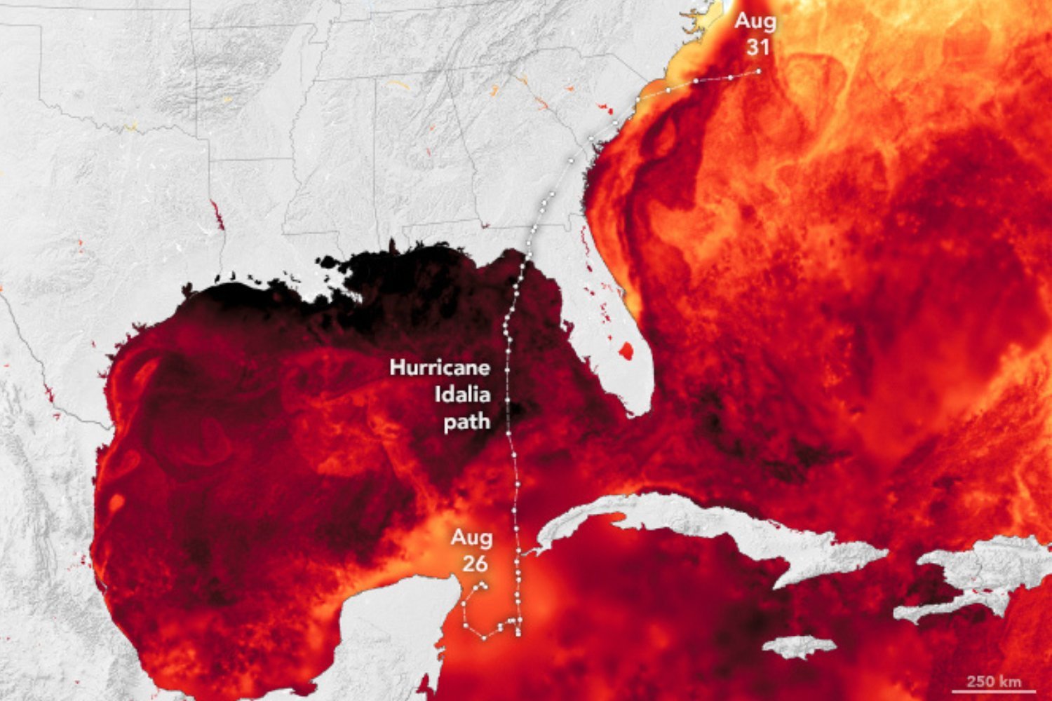
Hurricane Idalia’s trajectory carved a path through Florida’s Big Bend region before veering northeastward across the American Southeast. The storm underwent a rapid transformation, escalating from a Category 1 hurricane to a Category 4 storm in a short period. By the time it made landfall on August 30, 2023, Idalia had only slightly subsided to a Category 3 hurricane, packing maximum sustained winds of nearly 125 miles per hour.
The impact of Hurricane Idalia was widespread and devastating. The storm raised concerns about gas contamination, left hundreds of thousands without power, and even caused a tree to fall on the Tallahassee home of Florida Governor Ron DeSantis. The storm inflicted an estimated $3.6 billion in damages, making it the costliest of 2023. After wreaking havoc across Florida, Idalia continued its path across Georgia and the South Carolina coast before departing over the Atlantic on August 31.
The study of Hurricane Idalia’s formation offers valuable insights that could improve our understanding of the conditions that contribute to extreme storm development. In light of the study on Idalia, consider Hurricane Milton, which occurred in October 2024. Hurricane Milton shattered records when it rapidly intensified from a Category 1 storm to a Category 5 storm in just 7 hours after feeding on extremely warm waters in the western Gulf of Mexico. Category 5 storms represent the highest intensity on the Saffir-Simpson hurricane wind scale, requiring wind speeds exceeding 157 miles per hour. When Milton touched down in central Florida as a Category 3 storm, it spawned at least three dozen tornadoes across the state.
As ocean temperatures continue to rise and break records, we can expect to see more extreme and rapidly evolving hurricanes. The analysis of contextual factors like freshwater plumes in Idalia’s formation emphasizes the need for continued research into the complex interactions that drive hurricane behavior. By incorporating these findings into forecast models, authorities can be better prepared for the potential impacts of these storms.
With hurricane season resuming on June 30 and running through November 30, continued efforts to refine forecast models and incorporate new insights from research such as the study on Hurricane Idalia’s formation are essential. Only through improved understanding and preparedness can we mitigate the devastating effects of these powerful storms.