
National Hurricane Center Releases Report on Devastating Hurricane Helene
Nearly six months after Hurricane Helene carved a path of destruction across the southeastern United States, the National Hurricane Center (NHC) has released its comprehensive report on the storm. The report paints a stark picture of Helene’s impact, revealing the immense human and economic toll it exacted. With 248 lives lost and damages totaling $78.7 billion, Helene stands as a grim reminder of the destructive power of hurricanes.
The NHC report places Helene among the most costly and deadly hurricanes in recent history. In terms of economic damage, Helene ranks as the seventh-costliest storm on record in the United States, trailing only Katrina, Harvey, Ian, Maria, Sandy, and Ida. When considering fatalities, Helene is the fourth-deadliest hurricane to make landfall on the U.S. mainland since 1950, surpassed only by Katrina (1,392 deaths), Audrey (416 deaths), and Camille (256 deaths).
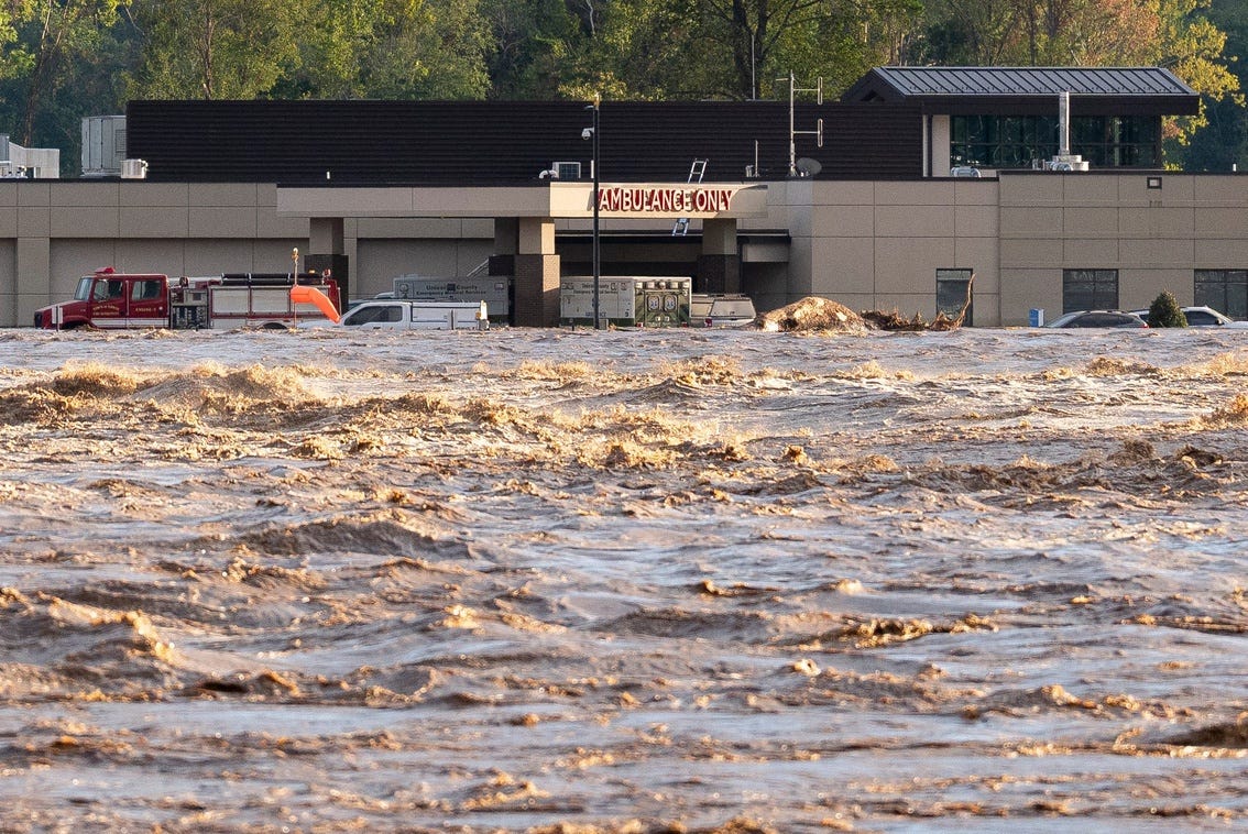
Helene’s impact extended far beyond the immediate coastline, with high winds, tornadoes, and torrential rainfall causing widespread damage and disruption across multiple states. The storm injured 117 people, necessitating high-water rescues for more than 2,700 individuals. Power outages affected a staggering 7.4 million customers between September 26 and 28, leaving many in the dark for days.
From its initial landfall near Steinhatchee, Florida, on September 26, Helene’s destructive path stretched through Tennessee and North Carolina. The report underscores the ongoing recovery efforts in these areas, where countless individuals are still struggling to rebuild their lives in the aftermath of the storm. Homes were destroyed, businesses were shuttered, and communities were left reeling from the combined effects of wind, rain, and flooding.
Despite challenges in obtaining precise wind measurements, the NHC report provides valuable insights into Helene’s intensity. The strongest sustained winds recorded over land were measured 35 miles inland in Live Oak, Florida, reaching 74 mph. These measurements were captured by an instrument from Texas Tech research. Taking into account the instrument’s height and location, as well as the time elapsed since landfall, the NHC estimates that sustained winds at landfall were approximately 91 mph.
Helene’s size and forward speed contributed significantly to its widespread impact. The hurricane’s massive size allowed for wind gusts to penetrate far inland, while its rapid movement propelled a devastating storm surge along more than 550 miles of the Florida coastline. The NHC report emphasizes that when Helene was still over the water, gaining strength off the coast of Southwest Florida, it was larger than 90% of historical systems of similar strength and location.
The report acknowledges the limitations in wind measurement infrastructure in rural areas, suggesting that higher winds may have occurred but were not captured by existing gauges. Regardless, the available data indicates that Helene’s winds remained potent even far inland. Roughly 75 miles from the coast, near Valdosta, Georgia, Helene still sustained winds of 61 mph, with gusts reaching 95 mph.
Helene’s central low pressure set all-time records as it moved through Florida and Georgia, further highlighting the storm’s unusual intensity. The combination of high winds and low pressure contributed to the storm’s destructive force.
The NHC report details the devastating effects of Helene’s storm surge, defined as the abnormal rise in water above normal tide levels. Elevated storm surges were recorded along a vast stretch of coastline, extending from Panama City Beach on Florida’s Panhandle more than 550 miles southward to the Florida Keys. High tides were also observed as far north as Charleston, South Carolina, indicating the storm’s widespread influence on coastal waters.
The Big Bend region of Florida bore the brunt of Helene’s storm surge, with inundation levels reaching 12 to 16 feet from just west of Keaton Beach through Steinhatchee. The NHC report describes the catastrophic damage in these communities, noting that many homes were completely removed from their foundations, leaving only slabs and stilts behind. Aerial imagery collected by NOAA revealed that entire homes were swept away by the storm surge and deposited in remote wetlands. The high water mark in Dekle Beach reached 15.3 feet above the mean higher high water line.
A gauge located two miles from the mouth of the Steinhatchee River measured a surge of nearly 10 feet before failing. A U.S. Geological Survey crew later found a high water mark of 14.25 feet nearby. This surge was significantly higher than the water level recorded during Hurricane Idalia two years earlier, illustrating Helene’s exceptional intensity in the region.
Even in the Tampa Bay area, located farther south, storm surge levels reached 5 to 7 feet, exceeding previous records. St. Petersburg, which has maintained records since 1947, experienced unprecedented surge levels during Helene.
Beyond the coastal impacts, Helene’s heavy rainfall also caused widespread flooding. The NHC report attributes the extensive flooding to a predecessor rain event that occurred as tropical moisture moved ahead of Helene. At least 63 stream and river gauges exceeded their record flood levels, including 14 that had been measured for 100 years. The saturated soils on mountainsides led to more than 2,000 landslides, as documented by the U.S. Geological Survey.
The NHC report underscores the long and arduous recovery process that lies ahead for communities affected by Hurricane Helene. The report’s findings will be crucial in informing future preparedness and mitigation efforts, helping to minimize the impact of future hurricanes.
The National Hurricane Center emphasized the importance of heeding warnings, following evacuation orders and being prepared for the aftermath of future storms.