
Extensive Rainfall Threatens Eastern and Southern US with Flash Flooding
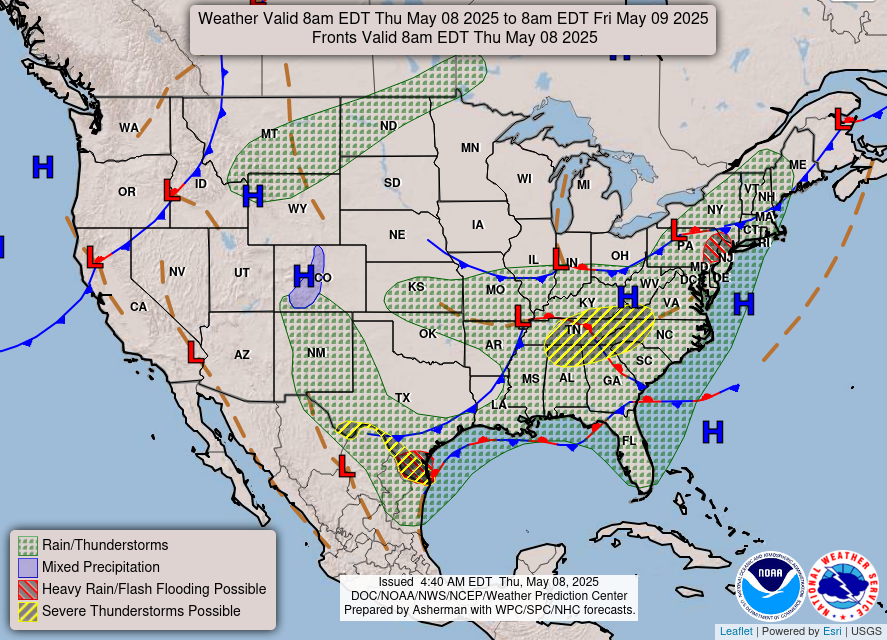
The eastern and southern regions of the United States are bracing for a wet end to the week as a widespread heavy rainfall event is expected to bring the potential for scattered flash flooding and thunderstorms to a vast area. The National Weather Service has issued warnings and advisories, highlighting the increased risk of hazardous weather conditions due to the anticipated precipitation. Residents are urged to remain vigilant and take necessary precautions to ensure their safety and protect their property.
The focal point of concern is the Northeast, where a significant portion of the population is currently under a flood watch. Early in the morning on May 8, nearly 4 million individuals residing in parts of New York, Vermont, Massachusetts, and Connecticut were placed under the flood watch, indicating a heightened possibility of flooding in these areas. The saturated ground conditions in many locations exacerbate the situation, making it easier for rainfall to accumulate and overflow drainage systems.
The weather pattern responsible for this widespread rainfall extends far beyond the Northeast. Showers and thunderstorms are predicted to develop across a broad swathe of the country. This area encompasses New England in the northeast, stretches southwestward through the Ohio Valley, and continues southeastward along the Gulf Coast, ultimately reaching Texas.
Texas, in particular, has been subjected to a barrage of severe weather in recent weeks. Repeated rounds of severe storms and flooding have already taken a toll on the state, causing significant damage and disruption. The incoming rainfall poses a further threat to areas that are still recovering from previous weather events.
The National Weather Service is closely monitoring the situation and providing regular updates on the evolving weather conditions. Meteorologists are employing advanced forecasting models and observational data to track the movement and intensity of the storms. This information is crucial for issuing timely warnings and advisories, enabling communities to prepare for potential impacts.
Flash flooding is a particularly dangerous type of flooding that occurs rapidly, often with little or no warning. It is typically triggered by intense rainfall over a short period, overwhelming drainage systems and causing water levels to rise quickly. The swift and powerful nature of flash floods can pose a significant threat to life and property, especially in low-lying areas and near waterways.
Thunderstorms, another component of the predicted weather pattern, can bring a variety of hazards, including heavy rainfall, strong winds, lightning, and even hail. These conditions can create dangerous driving conditions, damage property, and pose a risk of injury.
Residents in the affected areas are encouraged to stay informed about the latest weather forecasts and warnings. This can be achieved through various channels, including local news outlets, weather websites, and mobile apps. It is also important to have a plan in place in case of flooding or other severe weather events.
Preparing for potential flooding involves several key steps. First, it is essential to identify potential flood hazards in your area. This may include low-lying areas, floodplains, and areas near rivers or streams. Next, develop an evacuation plan in case you need to leave your home quickly. This plan should include a designated meeting place for your family and a route to higher ground.
It is also important to protect your property from potential flood damage. This may involve elevating valuable items, sealing basement windows and doors, and installing a sump pump. Additionally, consider purchasing flood insurance to cover any losses that may occur.
During periods of heavy rainfall, it is crucial to avoid driving through flooded areas. The depth of the water may be difficult to assess, and even a shallow amount of water can be enough to stall a vehicle. Additionally, floodwaters can be contaminated with sewage and other hazardous materials, posing a health risk.
If you encounter a flooded roadway, turn around and find an alternative route. Never attempt to drive through floodwaters, as this could put your life and the lives of others at risk.
When thunderstorms are in the area, it is important to take precautions to protect yourself from lightning. Seek shelter indoors in a sturdy building or a hard-top vehicle. Avoid contact with metal objects and stay away from windows and doors.
If you are caught outdoors during a thunderstorm, find a low-lying area and crouch down with your head between your knees. Avoid standing near trees or other tall objects, as these can attract lightning strikes.
The combination of heavy rainfall and thunderstorms poses a significant threat to the eastern and southern United States. By staying informed, taking precautions, and being prepared, residents can minimize their risk and ensure their safety during this period of inclement weather. The National Weather Service will continue to monitor the situation closely and provide updates as necessary. Remember to heed the warnings and advisories issued by authorities and prioritize safety above all else. Vigilance and preparedness are key to navigating this period of potentially hazardous weather conditions.