
Earthquake Captured on Camera: A Rare Glimpse of Earth’s Power
A recently surfaced video offers a chilling look at the raw power of an earthquake, capturing what appears to be the first-ever filmed instance of a ground rupture. The footage, taken during the devastating magnitude 7.7 earthquake that struck Myanmar earlier this year, shows the earth literally tearing apart at the surface.
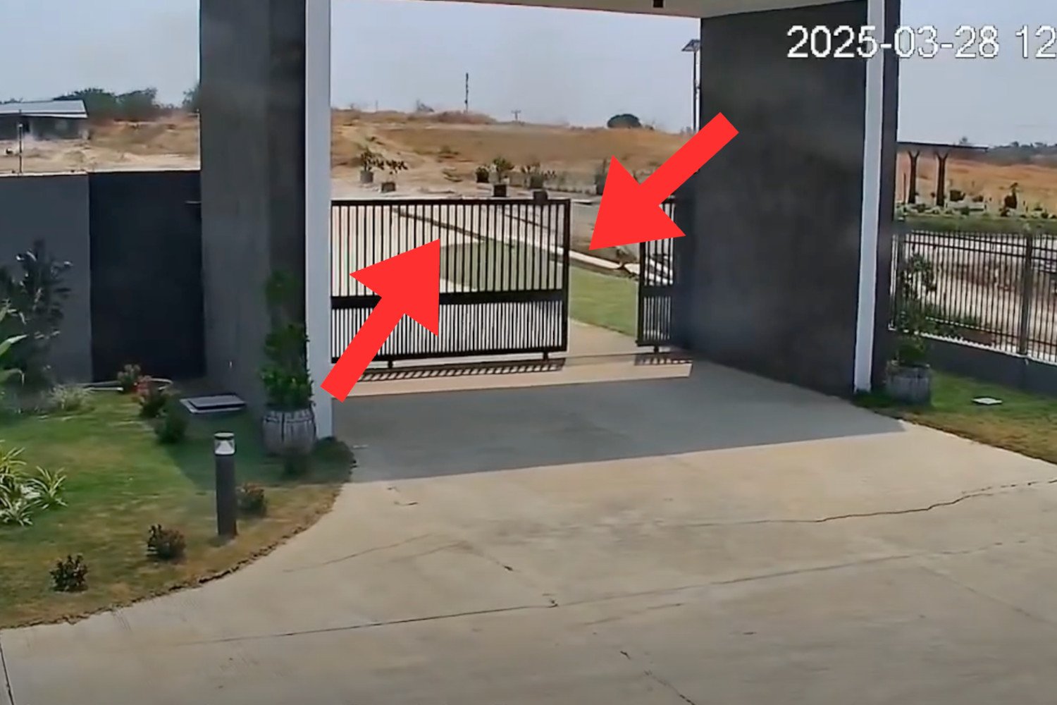
The video, which has quickly gained traction online, was reportedly filmed at the GP Energy Myanmar’s Thapyawa solar farm. It begins with a view of the property’s gated entrance and a long concrete driveway. For the first few seconds, everything seems normal. However, around the eight-second mark, the metal gate begins to vibrate violently. This is followed by a general shaking that intensifies rapidly.
Then, in a moment of terrifying force, the gate flies open. In the distance, a transmission tower buckles and sways precariously. The most dramatic event is yet to come: the entire right side of the scene suddenly slides forward relative to the left, revealing the earth’s violent movement.
The footage dates back to March 28th of this year, the date of the powerful earthquake that shook Myanmar. The quake and subsequent aftershocks resulted in a tragic loss of life, claiming over 3,600 victims and leaving thousands more injured. While the epicenter was located near the city of Mandalay, the impact of the earthquake was felt far and wide, even reaching Bangkok, the capital of Thailand.
The video’s significance lies in its potential to be the first documented recording of a ground or surface rupture. These ruptures occur when an earthquake’s force is so intense that it tears the Earth’s surface apart, creating visible cracks and displacements in the ground.
The video’s emergence on social media has sparked considerable interest in the scientific community. Singaporean engineer Htin Aung initially posted the footage on Facebook. From there, the 2025 Sagaing Earthquake Archive channel picked it up and republished it on YouTube, bringing it to a wider audience.
The YouTube post accompanying the video proclaims, "This is the first (and currently only) known instance of a fault line motion being captured on camera." This bold claim, while not yet definitively confirmed, highlights the video’s potential importance for earthquake research.
To understand the significance of this video, it’s crucial to understand the mechanics of earthquakes. Our planet’s surface isn’t a single, solid shell. Instead, it’s composed of numerous large pieces called tectonic plates. These plates are constantly moving, albeit very slowly, at a rate comparable to the growth of fingernails.
When these plates interact, pushing against or sliding past one another, immense amounts of energy build up. Eventually, this energy is released suddenly, causing the ground to shake violently – an earthquake. Regions where tectonic plates meet are known as fault lines, and these areas are particularly susceptible to earthquakes.
Myanmar is situated on the Sagaing Fault, a major geological feature that runs north-south through the country’s center. This fault line marks the boundary between the Sunda and Burma tectonic plates. The Sagaing Fault is classified as a strike-slip fault. In this type of fault, the tectonic plates slide horizontally past each other, rather than colliding head-on or one plate subducting beneath the other.
The video from Myanmar vividly illustrates this type of horizontal movement. The land on the right side of the frame abruptly slides past the land on the left, demonstrating the sheer force of the tectonic plates in motion.
Rick Aster, a geophysicist at Colorado State University, has commented on the video’s potential impact. “To my knowledge, this is the best video we have of a throughgoing surface rupture of a very large earthquake,” Aster told Live Science. He further added, “I have no doubt that seismologists will take a very close look at this. It will probably lead to some kind of a publication at some point.”
The implications of such a video for earthquake research are significant. It offers a rare opportunity to observe and analyze the dynamics of a ground rupture in real time. This data could potentially improve our understanding of how earthquakes propagate and the factors that influence the severity of surface deformation.
Perhaps the most well-known fault line globally is California’s San Andreas Fault. Like the Sagaing Fault, the San Andreas Fault is a strike-slip boundary. For decades, scientists have issued warnings about the potential for a massive earthquake along the San Andreas Fault, an event so powerful that it has earned the ominous nickname "the Big One."
Despite the ongoing research and advancements in seismology, predicting earthquakes with precision remains an elusive goal. The complex interplay of geological factors makes it incredibly difficult to forecast when and where an earthquake will strike.
The reality is that seismologists have not yet discovered a reliable method for predicting earthquakes with any reasonable degree of accuracy, and some believe that such a capability may never be achieved. Therefore, for those who live near fault lines, the most prudent approach is to be prepared for the inevitable.
Preparation involves understanding the risks, developing emergency plans, and ensuring that homes and buildings are constructed to withstand seismic activity. While we may not be able to prevent earthquakes, we can mitigate their impact through preparedness and resilience. The video from Myanmar serves as a stark reminder of the power of earthquakes and the importance of taking precautions to protect ourselves and our communities.