
A potent March storm system is poised to unleash a widespread and hazardous severe weather outbreak across a significant portion of the United States, spanning from the central regions to the eastern seaboard. Forecasters are warning of the potential for numerous strong tornadoes, along with widespread damaging winds, large hail, and the risk of flash flooding. This dangerous weather pattern is expected to unfold from Friday and persist throughout the weekend.
The greatest threat of tornadoes is predicted to materialize late Friday afternoon and continue through much of the night. This high-risk zone encompasses areas from central Missouri and northeast Arkansas extending into southern Illinois, western Kentucky, western Tennessee, and the northernmost parts of Mississippi. Residents in these areas are strongly urged to remain vigilant and prepared for the possibility of rapidly developing and potentially destructive tornadoes.
Beyond the tornado threat, the same powerful storm system has the capacity to generate other significant weather hazards. In the southern Plains, the storm could trigger clouds of dust and rapidly spreading wildfires, fueled by dry and windy conditions. Meanwhile, the northern Plains are bracing for blizzard conditions, characterized by heavy snowfall and strong winds, leading to severely reduced visibility and dangerous travel conditions.
As the storm system progresses eastward, it is expected to impact the East Coast by Sunday and Monday. This will bring with it the risk of severe thunderstorms stretching from Pennsylvania down to Florida. Residents along the East Coast should monitor weather forecasts closely and be prepared for the possibility of strong winds, hail, and heavy rainfall.
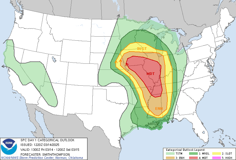
The Storm Prediction Center has issued warnings regarding a regional outbreak of severe storms expected to sweep across much of the Mississippi Valley, extending eastward into the Lower Ohio and Tennessee Valleys. This outbreak is anticipated to commence late Friday afternoon and continue into the early hours of Saturday morning.
Specifically, thunderstorms capable of producing tornadoes are expected to intensify rapidly over the Mississippi Valley states on Friday afternoon. Forecasters caution that this situation could quickly escalate into a very dangerous and life-threatening scenario in parts of Iowa, Missouri, and Arkansas. The threat is then expected to expand into portions of Nebraska and Minnesota before moving southward into northeastern Texas and Louisiana.
The Storm Prediction Center has identified several cities at greatest risk for tornadoes. These include Memphis, Tennessee; St. Louis, Missouri; and Des Moines, Iowa. Residents of these cities and surrounding areas should take extra precautions and have a plan in place in case a tornado warning is issued.
Adding to the danger, forecasters are particularly concerned about the potential for nighttime tornadoes. These tornadoes, which can strike after dark, are especially hazardous because people are often asleep and less likely to receive warnings in time to take appropriate action. AccuWeather senior director of forecasting operations Dan DePodwin emphasized the heightened risk, stating that strong tornadoes could strike after dark Friday, posing an extremely dangerous situation, especially during the overnight hours while many people are asleep.
Residents in potentially affected areas are urged to take immediate steps to prepare. This includes ensuring that storm shelters or safe rooms are ready for use and stocked with essential emergency supplies. These supplies should include items such as water, non-perishable food, flashlights, a weather radio, and extra batteries.
The northern Plains are bracing for significant snowfall, with several inches expected to accumulate, particularly in the Red River Valley of the North. In the Upper Midwest, an unusual weather pattern is predicted, with a surge of warm air bringing rain and/or severe thunderstorms followed by accumulating snow and potential blizzard conditions. AccuWeather meteorologist Matt Benz highlighted the unusual nature of this weather sequence.
Due to the anticipated snowstorm, the National Weather Service is advising people to consider delaying all non-essential travel. If travel is absolutely necessary, motorists are urged to drive with extreme caution. They should also consider taking a winter storm kit along with them, including items such as tire chains, booster cables, a flashlight, a shovel, blankets, and extra clothing.
High wind warnings have been issued by the National Weather Service for a large portion of the Plains. These alerts include major cities such as Dallas, Oklahoma City, Tulsa, and Amarillo. Wind gusts in the Plains could reach speeds of 60 to 80 mph on Friday, depending on the specific location.
Dry, warm, and windy conditions will create critical fire weather conditions across portions of the Plains on Friday and into the weekend. The National Weather Service is urging residents to exercise extreme caution to prevent wildfires.
The Storm Prediction Center is warning of extreme fire-weather conditions on Friday from parts of western Texas into southern Kansas, including parts of the Dallas-Ft. Worth metro area, Oklahoma City, Tulsa, and Wichita. Weather.com reports that for some areas, this represents the highest fire weather threat since 2009. Residents are strongly advised to avoid any activities that could potentially spark a fire, such as outdoor burning or using equipment that could generate sparks.