
Atlantic Hurricane Season Outlook: Cooler Waters Offer Hope, But Vigilance Remains
The annual Atlantic hurricane season, commencing June 1st, is a period of heightened awareness and preparedness for coastal communities stretching from the Caribbean Sea to the eastern seaboard of the United States. Forecasters diligently monitor oceanic and atmospheric conditions, attempting to predict the intensity and frequency of tropical storms and hurricanes that could potentially wreak havoc. This year, early indications suggest a slightly tempered outlook, though experts caution against complacency, emphasizing that multiple factors contribute to the unpredictable nature of these powerful weather systems.
One of the primary drivers of hurricane formation is warm ocean water. Hurricanes essentially feed on the heat energy stored in the upper layers of the ocean. As warm, moist air rises from the sea surface, it cools and condenses, releasing latent heat that fuels the storm’s intensification. The warmer the water, the more readily this process occurs, providing the necessary energy for hurricanes to develop and strengthen.
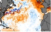
This year, meteorologists are observing a notable difference in sea surface temperatures compared to recent years, particularly in the eastern Atlantic Ocean, a region where many tropical storms originate. According to Weather.com meteorologist Jonathan Belles, a significant area of the eastern Atlantic is not warming at the typical rate expected for this time of year. This slower warming trend has prompted experts to reassess their initial expectations for the upcoming hurricane season and consider the potential mitigating effects of cooler waters.
Echoing this sentiment, Colorado State University hurricane researcher Phil Klotzbach highlighted the considerable difference in sea surface temperatures compared to the previous year. "Tropical sea-surface temperatures are thankfully much cooler than they were last year at this time," Klotzbach stated. He further elaborated that average sea surface temperatures are nearly 2 degrees cooler compared to the same period in 2024. While this temperature difference might seem insignificant to the average person, it represents a substantial variation in the context of meteorology and can significantly influence hurricane formation and intensity.
Klotzbach also offered a more nuanced perspective on regional temperature variations. He noted that while ocean temperatures in the Caribbean Sea and eastern subtropical Atlantic are slightly warmer than normal, the eastern tropical Atlantic is exhibiting cooler than normal temperatures. These regional variations underscore the complex interplay of factors that influence hurricane development and underscore the importance of considering localized conditions when assessing the overall risk.
The observations regarding cooler sea surface temperatures in the eastern Atlantic are particularly encouraging considering the alarming conditions observed last year. Klotzbach remarked that sea surface temperature anomalies in late April 2024 were "downright scary," leading to preseason predictions of a hyperactive hurricane season with the potential for numerous storms. While the 2024 season ultimately proved to be above average, with a total of 18 named storms, it did not reach the extreme levels initially anticipated.
This discrepancy between preseason forecasts and the actual outcome of the 2024 season serves as a reminder that ocean temperature is just one piece of a complex puzzle. Other atmospheric factors can also significantly impact hurricane formation, intensity, and track.
Belles emphasized the importance of considering these additional factors, including the presence of dry air or dust in the atmosphere, the influence of El Niño or La Niña climate patterns, and the presence of strong wind shear or prolonged periods of sinking air. Dry air and dust can inhibit hurricane development by suppressing convection and limiting the availability of moisture. El Niño and La Niña, which are characterized by variations in sea surface temperatures in the equatorial Pacific Ocean, can alter large-scale atmospheric circulation patterns, influencing the steering currents that guide hurricanes. Strong wind shear, which refers to variations in wind speed and direction with altitude, can disrupt the structure of a developing hurricane and prevent it from intensifying.
Despite the encouraging signs of cooler ocean temperatures, experts caution against complacency. Colorado State University’s most recent forecast, released in early April, still projects an active hurricane season, with as many as 17 named storms expected. Researchers further predict that nine of these storms will intensify into hurricanes. To provide context, a typical hurricane season, based on weather records from 1991 to 2020, averages around 14 tropical storms, with seven of them reaching hurricane status.
It’s important to remember that even if the overall number of storms is lower than average, a single powerful hurricane can cause catastrophic damage and loss of life. Therefore, coastal communities must remain vigilant and prepared, regardless of the preseason forecasts.
Colorado State University plans to release an updated forecast in early June, incorporating the latest available data and refining their predictions. The National Oceanic and Atmospheric Administration (NOAA) will also issue its official hurricane season forecast later in May, providing another valuable perspective on the expected activity.
In conclusion, while cooler ocean temperatures in the eastern Atlantic offer a glimmer of hope for a less punishing hurricane season, it is crucial to recognize the complex interplay of factors that influence these powerful weather systems. Coastal residents should stay informed about the latest forecasts and advisories, develop comprehensive hurricane preparedness plans, and take proactive measures to protect themselves, their families, and their property. Vigilance and preparedness remain the most effective strategies for mitigating the potential risks associated with the Atlantic hurricane season.