
Severe Weather Grips the Nation: From Deadly Flooding in the South to Potential Storms in the Northeast
The United States is currently grappling with a widespread and intense weather outbreak, leaving communities reeling from devastating floods, damaging winds, and the looming threat of tornadoes. From the south-central states to the West Coast and potentially extending into the Northeast, a complex web of weather systems is impacting millions, prompting urgent warnings and widespread concern.
The south-central region, already battered by days of torrential rainfall, faces the most immediate danger. Forecasters are predicting another wave of severe thunderstorms stretching from Tennessee and Kentucky, with intense clusters expected to unleash their fury on May 2nd. The primary concerns revolve around damaging wind gusts, potentially reaching significant speeds, and hail, particularly large in central Texas. The Storm Prediction Center is closely monitoring the situation, emphasizing the potential for a tornado or two to form amidst the volatile atmosphere.
The impact of the relentless rainfall is particularly acute in Oklahoma, where the ground is saturated and vulnerable. More than 1.1 million people in north Texas and Oklahoma were under a severe thunderstorm watch early May 2nd, underscoring the scale of the threat. The risk of flooding remains a significant concern, with a slight risk of excessive rainfall in the south-central region. The cumulative effect of days of heavy rain has already proven deadly, with recent flooding claiming lives in Oklahoma.
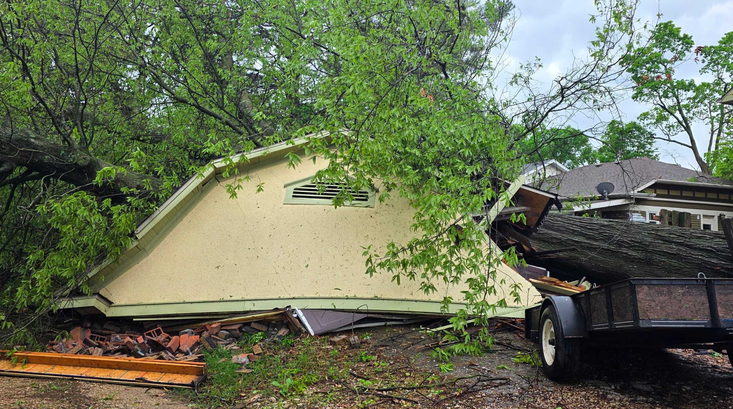
The end of April and the beginning of May have brought repeated rounds of severe weather to a large swathe of the country, stretching from Texas through upstate New York. At least five people have perished in recent days due to storms that brought severe winds to Pennsylvania and deadly flooding in Oklahoma. The situation highlights the inherent dangers of these weather events and the importance of preparedness.
Oklahoma City has experienced an unprecedented amount of rainfall, setting a new record for the wettest April in history. The city received an astounding 12.55 inches of rainfall in April 2025, pushing the total rainfall for the year to 15.54 inches. This surpasses the previous record set in April 1947, when Oklahoma City received 11.91 inches of rain.
The relentless downpour has overwhelmed infrastructure, causing a patched dam in northeast Oklahoma to fail. Creeks have overflowed, inundating roads and highways across the state, as reported by the Oklahoman, part of the USA TODAY Network. The severity of the situation prompted Governor Kevin Stitt to declare a state of emergency for three Oklahoma counties on April 30, recognizing the ongoing threat posed by heavy rain, flooding, and severe weather that began on April 19.
Memphis is also bracing for severe weather on May 2nd, as damaging winds, possible hail, and the threat of tornadoes loom over the city as it prepares for the RiverBeat Music Festival. The weather service in Memphis warns of wind gusts up to 70 mph, ping pong ball-sized hail, and a slight threat of tornadoes, particularly south of Interstate 40. While the threat is expected to decrease later in the weekend, scattered showers remain a possibility on May 3rd.
Meanwhile, on the West Coast, a different type of weather system is at play. Thunderstorms with rampant lightning developed rapidly on the afternoon of May 1st, triggering a flash flood warning for parts of California, including Los Angeles, Ventura, and Santa Barbara counties. The weather service in Los Angeles indicates a slight chance of more thunderstorms on May 2nd. AccuWeather warns that this weekend storm may mark the last rainfall across much of Southern California until fall. The region experienced a dryer-than-usual April, and residents are advised to prepare for a prolonged period of dry weather.
The storm front currently impacting the south-central region and Tennessee Valley is predicted to shift eastward and southward during the first weekend of May. This movement will bring the risk of showers and thunderstorms to the Northeast, Mid-Atlantic, Appalachians, and Southeast, according to the National Weather Service. Forecasters in Boston anticipate scattered showers and thunderstorms on the afternoon of May 3rd, with some of these storms potentially becoming strong to severe.
The weather service in Boston specifically warns of isolated strong to severe thunderstorms with the potential for locally strong and damaging wind gusts, hail, and brief torrential rainfall. Major cities along the East Coast, including New York, Boston, and Washington, D.C., are within the projected path of these storms, raising concerns about potential airline delays over the weekend, as noted by AccuWeather.
This widespread weather outbreak serves as a stark reminder of the power of nature and the importance of staying informed and prepared. Residents in affected areas are strongly advised to monitor local weather forecasts, heed warnings from authorities, and take necessary precautions to protect themselves and their property. This includes securing loose objects, avoiding flooded areas, and having a plan in place in case of a tornado or other severe weather event. Staying vigilant and proactive is crucial to mitigating the risks associated with these hazardous conditions.