
Devastating Storm System Unleashes Widespread Destruction Across the Nation
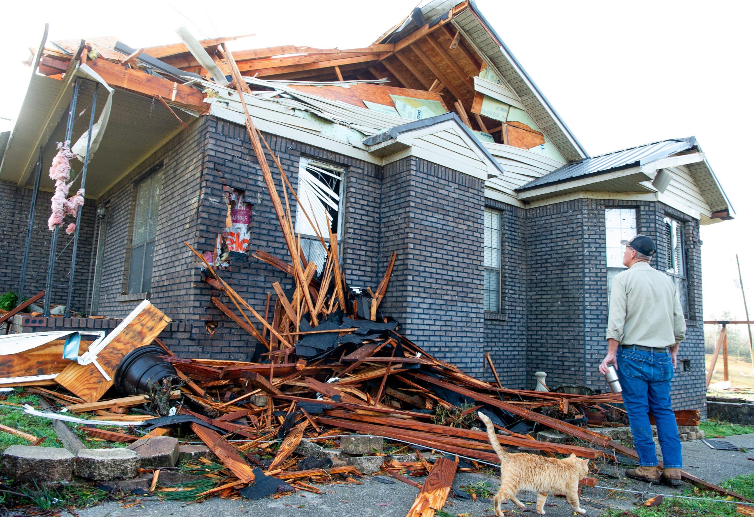
A ferocious storm system carved a path of destruction across the United States over the past weekend, leaving a trail of death, damage, and unprecedented weather events in its wake. The system spawned over 50 tornadoes, fueled raging wildfires, and triggered hazardous dust storms, resulting in a tragic loss of life, with at least 42 people confirmed dead across eight states.
The severity of the storm system far exceeded typical March weather patterns, prompting meteorologists to examine the underlying factors contributing to its unusual intensity. Evan Bentley, a mesoscale forecaster at the National Oceanic and Atmospheric Administration’s Storm Prediction Center, emphasized the exceptional nature of the outbreak, noting that the impact surpassed what is normally expected during the transition between winter and spring.
"The very strong system that developed in the Central Plains resulted in dust storms in the Southern Plains, extreme fire behavior in Oklahoma, blizzard conditions in the Northern Plains and then the severe weather Friday, Saturday and Sunday from the Midwest all the way across the East Coast," Bentley explained, painting a picture of the storm’s wide-ranging and multifaceted impact.
In the aftermath of the storm, the National Weather Service deployed survey teams to assess the extent of the damage and determine the precise number of tornadoes. The meticulous process of analyzing the devastation will take several days before final figures are available, according to Bentley.
The sheer volume of severe weather reports received by the Storm Prediction Center during the three-day period from Friday to Sunday underscores the magnitude of the event. Over 1,000 reports of tornadoes, high winds, and hail flooded in, nearly matching the average number typically received for the entire month of March.
Wind speeds reached alarming levels, with gusts of 70-80 mph recorded in numerous locations. By the end of Saturday, the weather service had documented 104 tornado reports. While some reports might have originated from the same tornado, meteorologists often uncover additional tornado evidence during post-storm surveys, even if no real-time reports were initially received.
As of Monday afternoon, the weather service had confirmed over 50 tornadoes, including seven with EF3 strength and two with EF4 strength. The numbers are expected to climb as survey teams continue to analyze the damage. In Arkansas, the weather service identified two separate tornado tracks caused by EF4 tornadoes on March 14, one in Jackson County and the other in Izard County. According to Meteorologist Colby Pope, the last time Arkansas experienced more than one EF4 tornado on the same day was March 1, 1997.
The EF3 tornado that struck Bakersfield, Missouri, reached peak winds of 140 mph, overturning vehicles, demolishing homes, and claiming three lives. Some tornadoes traveled exceptionally long distances, with one tracing a path of over 24 miles. The length of these tornadoes adds to the complexity of the post-storm surveys.
The Jackson, Mississippi, weather service office highlighted the challenges faced in their area, which experienced at least eight tornadoes. Their assessment mentioned "long paths, complications from crossing tornado paths and road accessibility issues" as factors hindering the survey process.
The Enhanced Fujita Scale, or EF Scale, is used to classify tornadoes based on the damage they inflict. It ranges from EF0, the weakest, to EF5, the most intense. The estimated wind speeds are derived from the damage observed along a tornado’s path.
Meteorologists attribute the unleashing of nature’s fury to a confluence of atmospheric conditions. A massive weather system originating over the Pacific Ocean moved towards the West Coast, setting the stage for the severe weather outbreak.
As these Pacific Coast systems cross the Rocky Mountains and enter the Great Plains and Central U.S., they often lead to the formation of low-pressure areas. The unique geography of the region, which combines dry air from the Desert Southwest with moisture-rich air from the Gulf of Mexico, makes it particularly susceptible to tornado formation. This is why the area is known as the tornado capital of the world.
Bentley explained that, in this particular case, strong winds in a high-altitude jet stream interacted with very dry air from the Desert Southwest and unusually warm, moisture-laden air from the Gulf of Mexico. The barometric pressure readings dipped below 980 millibars, a level typically associated with a Category 1 hurricane.
"Sometimes the March systems come through and the right ingredients aren’t all there," Bentley said. "It may be too dry or the Gulf moisture hasn’t moved far enough north yet. The warmer the Gulf temperatures, the higher the moisture content and the greater likelihood that moisture will push inland."
Sea surface temperatures in certain areas of the Gulf of Mexico have been running five degrees or more warmer than normal. The unusual warmth contributes to increased moisture content in the atmosphere, further intensifying the potential for severe weather.
As of Monday afternoon, officials reported 42 deaths across eight states. These fatalities resulted from a variety of causes, including multi-vehicle accidents during dust storms, wildfires exacerbated by high winds, and the direct impact of tornado damage.
The losses are deeply felt across the impacted communities, underscoring the devastating power of nature and the importance of preparedness and vigilance in the face of severe weather threats. The recovery process will undoubtedly be long and challenging, but communities are uniting to support those who have lost loved ones, homes, and livelihoods.
Dinah Voyles Pulver, who covers climate change and the environment for USA TODAY, has been reporting on hurricanes, tornadoes, and violent weather for over 30 years.