NASA Satellite Images Reveal Devastating Tennessee and Kentucky Floods
A Force of Nature
A relentless winter storm system has ravaged the East Coast, leaving a trail of destruction in its wake. Particularly hard-hit are the states of Tennessee and Kentucky, where relentless rainfall has triggered severe flooding, as evidenced by newly released NASA satellite images.
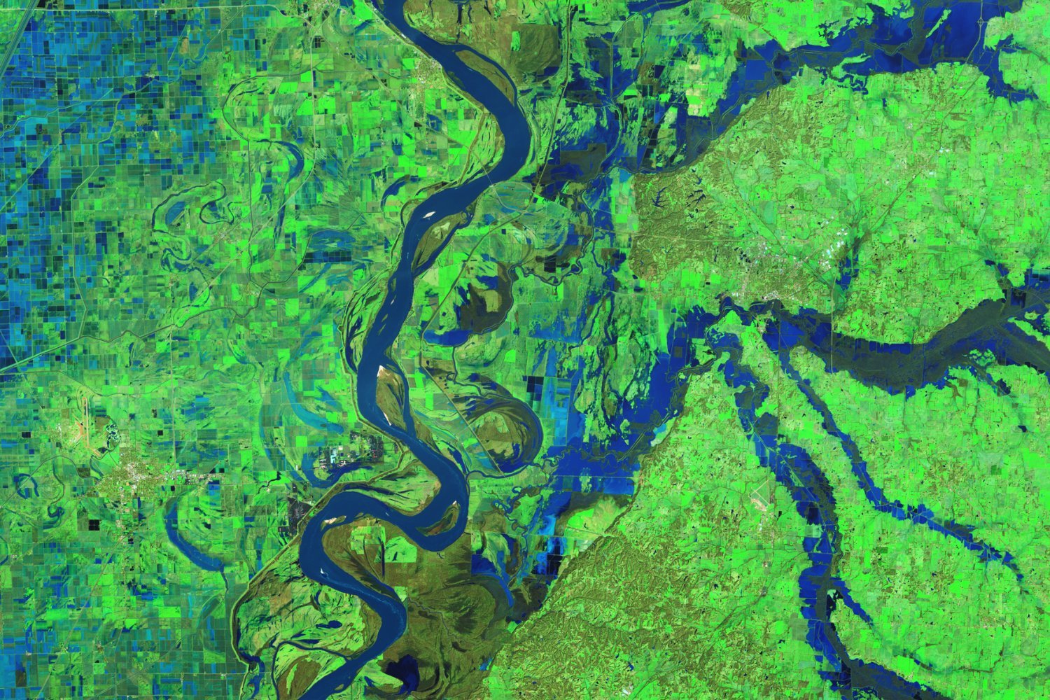
These images offer a sobering glimpse into the extent of the disaster, capturing the Mississippi River’s meandering course through western Tennessee, eastern Arkansas, and Missouri. However, the most striking feature is the widespread inundation of rivers and water bodies east of the Mississippi in Tennessee, where up to 6 inches (15 centimeters) of rain deluged the land over a mere 48-hour period.
The magnitude of the flooding has necessitated a state of emergency in Tennessee, precipitated by a catastrophic levee failure near the town of Rives, on the Obion River – the overflowed waterway seen in the top-right corner of the satellite image.
A Weather Extravaganza
This past week has been a tumultuous one for weather patterns across the United States. More than half of the states have been subjected to winter weather advisories, while 11 states have braced themselves for flash flood watches. The West Coast has not been spared either, with California enduring mudslide-triggering rains. Amidst this meteorological pandemonium, the catastrophic flood conditions in Tennessee and Kentucky have stood out as a particularly dramatic example of nature’s wrath.
High-Tech Imaging
NASA’s Operational Land Imager-2 (OLI-2) instrument, aboard the Landsat 9 satellite, has captured false-color images of the affected rivers in western Tennessee on February 17. These images utilize specific color bands to enhance the visibility of water, land, and vegetation, providing a comprehensive visual representation of the disaster.
A Record-Breaking Deluge
According to the National Weather Service, the majority of the torrential rain occurred on Valentine’s Day. The unrelenting downpour has resulted in at least a dozen river sites experiencing crests within the top five recorded crests in history. Kentucky has borne the brunt of the damage, with 30 flood warnings, 47 flash flood warnings, 11 severe thunderstorm warnings, and two tornado warnings issued by authorities. The devastating impact has included the closure of over 300 roads and tens of thousands of residents left without power.
Staggering Water Levels
Data from a U.S. Geological Survey water gauge in Obion, Tennessee, paint a grim picture of the flood’s severity. The gauge recorded a staggering water level of 39.8 feet (12 meters) on February 17 – a level that surpasses the flood stage by a significant margin (any water level exceeding 34 feet or 10.4 meters is considered a flood stage).
Hydrological Insights
Hydrographs depicting the affected rivers in Kentucky can be found on the National Weather Service’s website. Unfortunately, cloud cover over the state has prevented satellites from capturing similar images north of Tennessee, where some of the most destructive flash flooding has occurred.
Winter’s Icy Grip
As if the flooding were not enough, Mother Nature has another unwelcome surprise in store for the affected areas. The weather service predicts flurries and snow showers in western Kentucky today, with temperatures hovering in the low 20s – a stark contrast to the recent flooding. The snowy conditions are also expected to affect southeastern Illinois and southwestern Indiana.
The relentless onslaught of weather events serves as a potent reminder of nature’s unpredictable and often destructive power. The satellite images released by NASA provide a stark and sobering portrayal of the devastation wrought by the winter storm system, highlighting the need for preparedness and resilience in the face of such formidable challenges.
